Standard Aerial Photography UK - Property, Land and Development Surveys
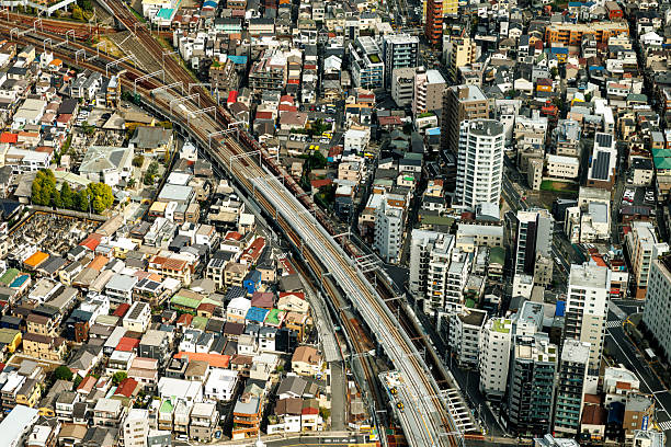
Standard aerial photography provides high-resolution images of property, land and development sites from an elevated perspective. Across the UK, developers, investors, landowners and property professionals use aerial imagery for site assessment, development planning, construction monitoring, property marketing and land due diligence.
Unlike specialist LiDAR or multispectral surveys, standard aerial photography primarily captures conventional visible-light imagery. Drone technology has made detailed aerial images increasingly practical for individual properties, development sites, agricultural land and larger estates.
FraserBond.com supports developers, investors and landowners with property sourcing, acquisitions, sales, lettings, compliance-focused support and investment advisory across London and the wider UK property market.
What Is Standard Aerial Photography?
Standard aerial photography involves capturing photographs of land, buildings or infrastructure from the air.
Images may be taken using drones, aircraft or other suitable aerial platforms. For property-specific projects, drones can provide detailed imagery from different elevations and viewing angles.
Potential applications include:
- Development site photography
- Property and land surveys
- Construction progress records
- Roof and external building inspections
- Agricultural land photography
- Estate and boundary context
- Commercial property documentation
- Property marketing
- Regeneration project monitoring
The appropriate method depends on the size, location and purpose of the project.
Drone Aerial Photography for Property
Drone aerial photography can provide developers and investors with a detailed overview of a property and its surroundings.
Ground-level photography may not clearly show the relationship between buildings, boundaries, access routes and neighbouring land. Aerial imagery can provide this broader context.
For development opportunities, images can help project teams understand the site's existing configuration before more detailed technical investigations are undertaken.
However, aerial photography should not be treated as a substitute for a measured survey where precise dimensions, coordinates or levels are required.
Aerial Photography for Development Sites
Aerial photography for property development can be particularly useful during initial site assessment.
Developers can use aerial images to review the existing site layout, buildings, access arrangements and surrounding development.
This can support early discussions with architects, planners, engineers and investors.
For larger development opportunities, aerial imagery can also communicate the scale and context of a site more effectively than ground photographs alone.
Through FraserBond.com, developers can identify and assess UK development opportunities while specialist aerial survey providers deliver the imagery and technical information required for individual projects.
Aerial Photography for Construction Progress
One valuable application is construction progress photography.
A developer can commission aerial photography at agreed stages throughout construction, creating a visual record of how the project progresses.
Regular imagery can help document:
- Site preparation
- Groundworks
- Structural construction
- External works
- Landscaping
- Overall project progress
This information can be useful for developers, investors and other project stakeholders.
Aerial photography does not replace formal construction monitoring, building-control inspections or professional certification where these are required.
Aerial Photography for Property Inspections
Drone photography can provide visual access to areas that may be difficult to inspect from ground level.
Examples include roofs, façades, chimneys and large commercial buildings.
High-resolution imagery may help identify visible deterioration or areas requiring further investigation.
Where defects are suspected, photographs should be reviewed by an appropriately qualified building surveyor, structural engineer or other relevant professional.
A drone image can highlight a potential issue, but it does not by itself provide a complete technical diagnosis.
Standard Aerial Photography vs Photogrammetry
Although both techniques use photographs, standard aerial photography and photogrammetry have different objectives.
Standard aerial photography primarily produces visual images for inspection, documentation, assessment or marketing.
Photogrammetry uses multiple overlapping photographs and specialist processing to derive measurements and create outputs such as 3D models, point clouds and orthophotos.
Where visual documentation is sufficient, standard aerial photography may be appropriate.
Where accurate spatial measurements or detailed digital models are required, photogrammetry or another surveying method may be more suitable.
Standard Aerial Photography vs LiDAR
LiDAR surveying uses laser pulses to produce detailed three-dimensional measurements, whereas standard aerial photography captures conventional visual imagery.
LiDAR can be appropriate where accurate terrain or structural data is required.
Standard photography can be more appropriate when the principal objective is to document how a property or site looks from the air.
The technologies can also complement each other. A major development project might use aerial photography for visual records while employing LiDAR or topographical surveying for technical design information.
Aerial Photography for Agricultural Land
Standard aerial photography can also provide useful information for farmland and rural estates.
Images can document field layouts, visible land conditions, access routes and the wider relationship between different parts of an estate.
However, conventional RGB photography differs from specialist multispectral agricultural surveys.
Where the objective is to calculate crop health indices such as NDVI or NDRE, specialist sensors and analytical techniques may be required.
Standard imagery is therefore most useful for visual assessment rather than advanced crop-health analysis.
Aerial Photography in London
Aerial photography in London can support residential, commercial and mixed-use property projects.
Developers may use aerial imagery to document existing buildings, constrained development sites and neighbouring property context.
Commercial property owners can use drone photography for external inspections or asset documentation.
London's dense urban environment means aerial operations require careful planning. Airspace, surrounding buildings, people, privacy and other operational considerations can affect whether and how a drone flight can be undertaken.
Appropriate UK aviation requirements and site-specific restrictions should always be considered by the operator.
FraserBond.com provides London property sourcing, acquisitions, sales and investment support, while qualified aerial survey specialists can undertake the required drone or aerial photography.
Aerial Photography for Property Marketing
High-quality aerial images can also strengthen the presentation of selected properties and development opportunities.
They can be particularly effective for development land, country estates, commercial assets, residential developments and properties with significant grounds.
Aerial images can show the scale of an asset and its relationship with surrounding locations in a way conventional photography cannot.
For development sales, this wider perspective can help prospective purchasers understand access, neighbouring uses and the overall site configuration.
Aerial Photography and Property Due Diligence
Aerial imagery can form part of broader property acquisition due diligence.
An investor considering a large site may use current imagery to understand its physical context before commissioning more detailed investigations.
Developers can similarly use aerial photography alongside topographical surveys, LiDAR, photogrammetry, measured building surveys and infrastructure assessments.
The appropriate combination depends on the property and intended strategy.
Legal, planning, environmental and technical due diligence should still be undertaken separately where relevant.
Property and Development Support from Fraser Bond
Fraser Bond works with developers, investors, landowners, landlords and property companies evaluating opportunities across London and the UK.
Through FraserBond.com, clients can access development site sourcing, property acquisitions, sales, lettings, compliance-focused support and investment advisory.
For clients undertaking development or acquisition due diligence, Fraser Bond can provide location-specific property intelligence while suitably qualified drone operators, surveyors and technical consultants provide aerial photography and specialist survey services.
Visit FraserBond.com to explore London and UK property opportunities and discuss development sites, acquisitions, disposals and investment requirements with Fraser Bond.